Introduction of COMS (Communication, Ocean and Meteorological Satellite)
Korea’s first geostationary multi-purpose satellite which is stationed at an altitude of 36,000 km above the Earth’s equator and at a longitude of
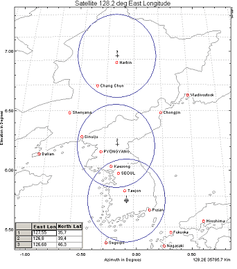
128.2°E performing the duties of meteorological and ocean observations and communications services.
A joint project that started in 2003 by the KMA (Korea Meteorological Administration), MEST (Ministry of Education, Science & Technology), MLTM
(Ministry of Land, Transport and Maritime Affairs), and KCC (Korea Communications Commission) in accordance with the Mid and Long-term
National Space Development Plan.
Korea Aerospace Research Institute is the project leader and responsible for the overall development. EDAS Astrium of France and ITT of the
United States are the foreign partners involved.
Launched successfully from the Guiana Space Center, Kourou in French Guiana, South America on June 27, 2010.
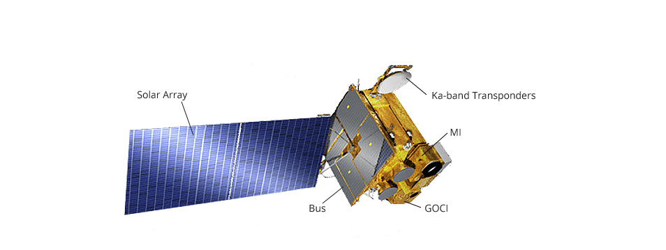
COMS configuration
- Dimensions: 2.2 × 2.4 × 2.6m
- Mass at launch: 2.5 tons
- Operational life: 7 years
- Manufactured by: KARI (Korea Aerospace Research Institute) and EADS Astrium of France
Changes brought on with development of geostationary meteorological satellite
Before the launch of COMS
- Received meteorological satellite data from Japan and other countries every 30 minutes
- Observation areas and observation times could not be adjusted
Forecasts based on simple image analysis were possible
After the launch of COMS
- The operation of our own meteorological satellite made intensive monitoring of extreme weather conditions possible through observing over the Korean peninsula with maximum 8-minute interval.
- In case of an extreme weather situation, it is possible to adjust independently the observation areas and times around the Korean peninsula.
- It is possible to generate data to support image analysis, our own data processing systems, and a numerical forecast.
Missions of COMS
Meteorological Missions
- Continuous monitoring of imagery and extracting of meteorological products
- Early detection of severe weather phenomena
- Monitoring of climate change and atmospheric environment
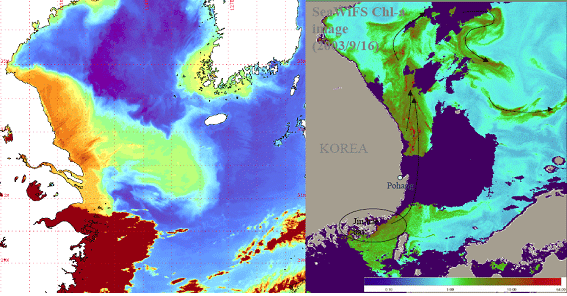
Maritime Missions
- Monitoring of marine environment and marine ecology of seas surrounding the Korean peninsula
- Generation of chlorophylls production estimates and fishery information
Communications Missions
- Broadband satellite multimedia testing services
- Korean Ka-band Transponders space certification
Overview of Meteorological Payload
Production: ITT of the United States
It has the same performance characteristics as the meteorological sensors mounted on GOES-8 ~ 13 of the U.S. and MTSAT-2 of Japan.
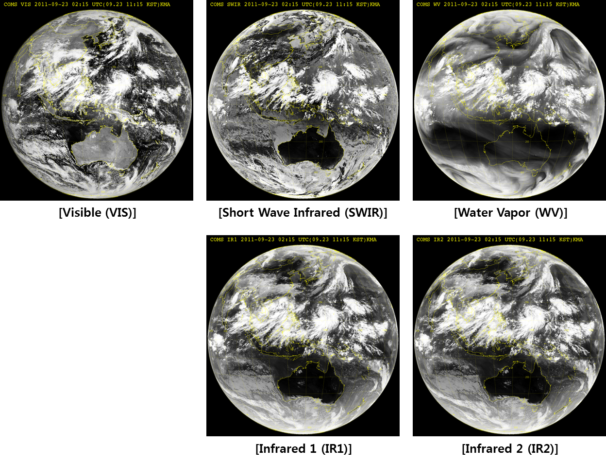
Basic Performance Data
| Number of Channels | 5 channels (1 visible, 4 infrared) |
|---|---|
| Observation Period | Less than 27 minutes |
| Channels | Wavelength(㎛) | Spatial Resolution | Applications |
|---|---|---|---|
| Visible | 0.67 | 1Km | Weekly cloud images, Asian dust, forest fires, fog observation, atmospheric motion vector |
| Shortwave infrared | 3.7 | 4Km | Night fog & low-level clouds, forest fire detection, land surface temperature |
| Water vapor | 6.7 | 4Km | Observation of mid and upper atmospheric humidity & upper atmospheric motions |
| Infrared 1 | 10.8 | 4Km | Cloud information, sea surface temperature, Asian dust observation |
| Infrared 2 | 12.0 | 4Km | Cloud information, sea surface temperature, Asian dust observation |
24-hr continuous monitoring of weather changes along with securing Korea’s first 24-hr continuous observation by infrared channels
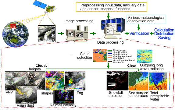
COMS Meteorological Data Processing System (CMDPS) Development
- Generation of 16 types of analysis data using the L1B data of COMS
- Data used in weather forecasting & numerical forecasting input data, prediction of climate changes
- Meteorological Data Processing System calculates meteorological elements
| Computation Sources | Contents | Applications |
|---|---|---|
| Cloud detection | Presence of clouds information | Weather and numerical forecast |
| Clear sky radiance | Estimation of radiation level in cloud-free region | Weather and numerical forecast |
| Atmospheric motion vector | Trace movement path of water vapor | Numerical forecast |
| Sea surface temperature | Sea surface temperature | Numerical forecast & climate monitoring, ocean |
| Land surface temperature | Land surface temperatures of regions in East Asia | Numerical forecast & climate monitoring |
| Sea Ice/Snow detection | Estimate sea ice & snow covered regions | Numerical forecast & climate monitoring, Asian dust prediction |
| Insolation | Solar energy reaching the ground | Agricultural meteorology, climate research |
| Upper tropospheric humidity | Vapor amount in the upper troposphere | Numerical forecast & climate monitoring |
| Total precipitable water | Total vapor amount in troposphere | Numerical forecast & climate monitoring |
| Cloud analysis | Estimation of shapes & amount of clouds & characteristics of cloud particles | Numerical forecast & climate monitoring |
| Cloud top temperatures & heights | Estimate the temperatures & heights at the cloud tops | Numerical forecast & climate monitoring |
| Fog | Fog detection by separating low cloud and fog | Aviation meteorology |
| Rainfall intensity | Rainfall intensity depending on the types of clouds | Weather and numerical forecast |
| Outgoing long-wave radiation | Estimation of earth’s long-wave radiation at the top of the atmosphere | Numerical forecast & climate monitoring |
| Aerosol index | Observation of Asian dust in the atmosphere | Asian dust forecast & environment monitoring |
| Aerosol optical depth | Estimation of atmospheric turbidity due to aerosol | Asian dust forecast, environment monitoring, & climate research |